Swedish late cold war air defense system
Posted: Mon Feb 20, 2023 11:06 pm
In the later half of the cold war Sweden set up a fairly intricate air defense command and control system. This was necessitated by the increasingly complex threat picture, and the expected fast paced nature of incoming attacks. Meanwhile it was observed that very complicated and capable systems were emerging abroad, not in the least in the form of SAGE in the US. In the 1950's the Swedish setup was still very manual in nature, and increasingly unworkable. In short it was a modified version of the one that the UK had used during WWII, with a lot of manual processing in control centers and pieces being moved around on large battle maps. The situation had improved slightly by adding in some radar feeds directly to these centers, but it was still apparent that the system was inadequate for future needs.
As a result a very ambitious plan was enacted wherein the command and control would be exercised largely with the aid of computers and datalinks, and fortunately it was decided to go with digital computers rather than a more analog version. This meant that it was possible to keep updating the system, adding elements and functions up until the last parts of it were shut down in 2001. The name for the system as a whole was STRIL 60, replacing the above described STRIL 50, and later replaced by STRIL 90 which is still in use.
So how did it work then? The system in total was quite complex and the below will be a simplified overview, but the two main components were the LFCs and the RRGCs.
The LFCs were the top level command posts who made the overarching decisions within an air defense sector, compiled information, and coordinated with other sectors. Early on it was clear that the increasing amount of information by way of numerous radar stations and such meant that the LFC would be swamped with data, and so what is known in English as a low altitude filter central was added to the system. These were called RRGC, and they compiled data from a number of radars each, and also handled most of the fighter control for intercepts. The data was also sent to the relevant LFC to add to the overall air picture, and the LFC in turn prioritized between incoming raids, fighter disposition and so on, and the RRGC then executed intercepts.
The LFCs came in three types, I, II and III.
Type I was the most capable of the three, and also the first to be built at around 1964. Two facilities were completed and these are also the ones there are the least public information on in terms on how they were layed out, the reason being that the facilities were converted to STRIL90 use and are still in operation as such. What is known is that they were deep underground command posts and had a large number of operators working from a number of rooms and from individual computer consoles, but also presentation of information on large screen projectors. These also had operator stations for controlling fighters directly, and were thus not necessarily dependent on the RRGCs for this, three fighter control rooms with four operators each handled this. Fully staffed the command posts had 73 operators filling 37 different roles and apart from the aforementioned ones could also control Hawk and Bloodhound batteries via datalink.
Basic data:
19 operator rooms.
73 operator stations for 37 different operator roles
50 primary radar consoles (PPI)
27 synthetic radar consoles (SPI)
3 large screen projectors (color)
24 vector indicators.
49 tables indicators.
25 digitron indicators. (I don't even know what those are.)
18 TV cameras.
43 TV monitors.
The TV cameras and monitors were a way to distribute the relevant information across the different operator rooms. Manual tables were kept for information such as meterological and force disposition which did not change fast enough that they couldn't be updated by a human, and were then displayed on internal TV channels along with the digital feeds such as the overall air picture. This was in part a way to work around the constraints of the time regarding the display of digital data in multiple locations, the computer system itself displayed it in one location and then it was copied via the TV feed.
The computer setup itself were housed in a 500 square meter large computer room and it enabled the automated handling of the air picture in a 1,023 and 3/4 square kilometer area. The resolution was 1/4 kilometer.
The requirement, and original plan, was for several more modern command posts though, but budget issues prevented that. As a result a plan was conceived for converting a number of the pre-existing older style command posts into functional ones. Still expensive but less so. These were called the Type IIs, four of these were eventually brought online. They were also hardened underground ones, but to a lesser degree than the Type Is as these had originally been built prior to the advent of highly accurate nuclear weapons. The electronic setup was also somewhat different than the Type I, as these excluded the fighter controller function and were also laid out around a central command room. These were referred to as the "church" due to their high ceiling height.
A few photos of these exist:
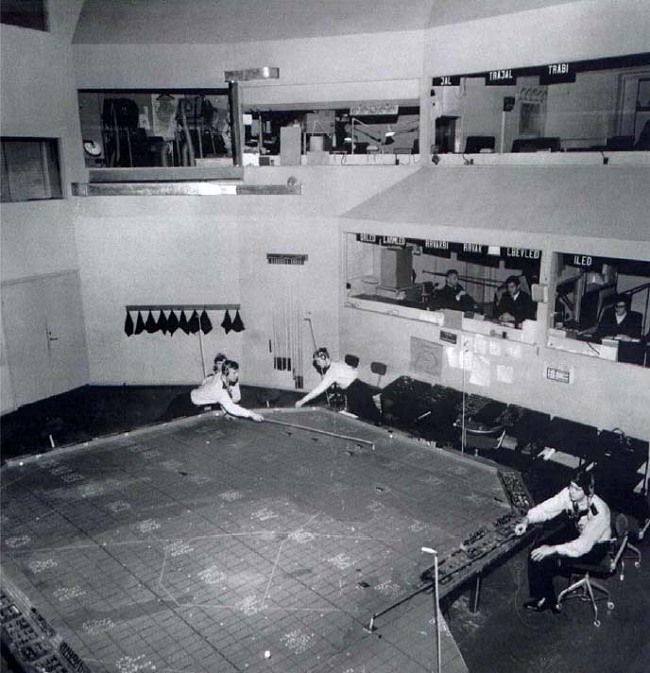
Unlike the Type I these also retained the manual chart table from their predecessors, this was also a cost cutting measure as it was used to plot the input from visual air observers rather than feeding it into a digital system which would have required more operator stations and such. The observers were kept around for a long time even after radars became the norm, this seems to have been due to two main reasons. Firstly, in the event that all radars were taken out in an area they still offered some basic idea on if air raids were happening, allowing some degree of early warning to areas further away. Secondly, they could observe and report on nuclear detonations with direction, distance and mushroom cloud height quickly. This enabled some degree of quick overview to what targets had been hit and at what yields. These reports were received by telephone by another type of command post called the LGC before being transmitted to the LFC for inclusion in the air picture. The LGCs also acted as emergency backups to the LFCs, with a largely manual handling of the air picture in case the LFCs were taken out.
The manual table can be seen better here:
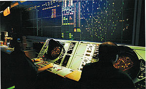
The digital radar information was however displayed by projectors on the large wall as seen in the photos above, and was data linked between the LFCs and RRGCs. On the sides raid designations and other data such as altitudes and speeds were displayed. It also came with some fairly modern functionality, such as the ability to display cursors (controlled by trackballs from three stations) that could be used to point to raids and such while giving orders to the RRGCs over voice link. An oddity with these complicated big screen projectors was in the way the past track of each raid was displayed, this was done by a laser continuously burning tiny holes in a plastic film that the projection was displayed through. These holes then appeared as dots trailing each raid and indicating the past position. When desired, an operator cycled the plastic film forward with a button press and the past tracks cleared. This was a pragmatic way of avoiding to tie up processing power that would otherwise have been needed to display this.
The final LFC type was the type III. This was a single command post that got a much more modest upgrade, without the big screen projectors. It seems to have not done much in the way of actual commanding but was rather kept to act as a sort of filter central for the visual air observations in the area, the closest higher end command post would have otherwise have had to handle too much of this information on its own.
So the RRGCs then, can be split into two groups. The RRGC/F, and the RRGC/T. The F ones were fixed hardened ones, and the T ones were mobile setups. Originally it was only planned for the fixed variety, 13 in total, but budget cutbacks limited these to just 8. As a fix four mobile variants were later developed, with the equipment mounted in a number of trailers each.
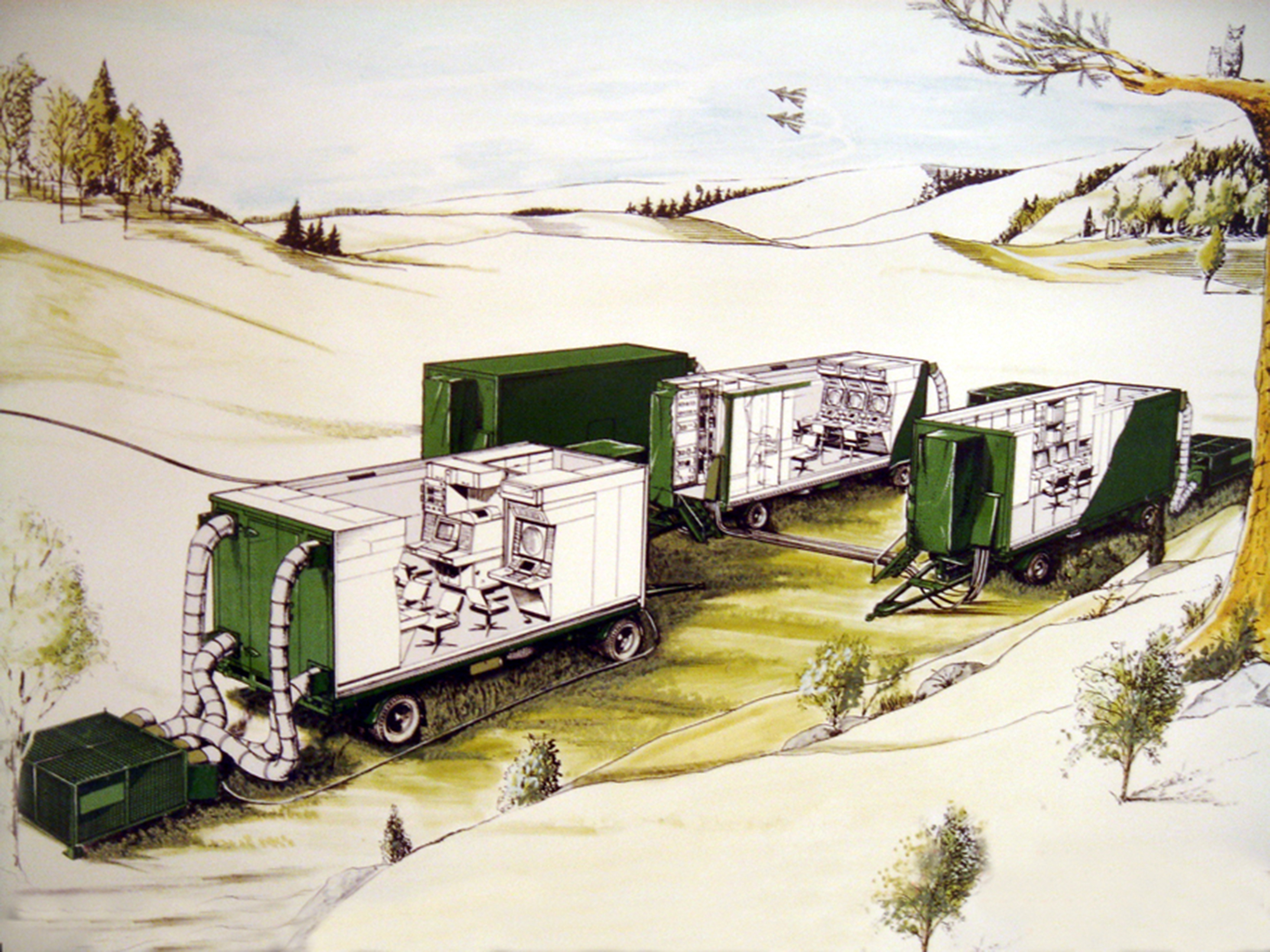
These were in peacetime normally set up above ground at air bases but would at certain readiness states move out and set up at one of a number of prepared wartime locations. At least one had its primary location inside a hardened space adjacent to an LFC, in other cases they were intended to set up in a hardened space by a radar station, as seen here:
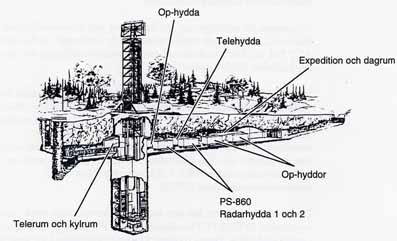
One advantage with the overall setup of the air defense communications system and datalinks was that there were a fairly large number of locations that these could hook into the net and operate from, so it made it harder to determine where they were and take them out.
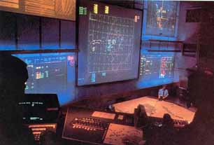
Interior shots of an RRGC/F:

The were some capability differences between the two. The RRGC/Fs could handle a 1,024 square kilometer area up to an altitude of 39,800 meters. The RRGC/Ts could handle a 2,048 square kilometer area to the same altitude. The F could track 73 raids simultaneously and pass on information on 70 of these to LFCs or other RRGCs via datalinks, whereas the T could track 72 raids and pass on information on 60 of these. The T could receive information on 143 raids from other centers, but I don't know what the corresponding figure is for the F. The F could direct 16 intercepts at the same time while the T could only handle 12.
Overall the system was very modern, and capability kept being added to it. Early on one way datalink functionality to interceptors were added which enabled the RRGCs (and type I LFCs) to send intercept commands digitally to Draken fighters. These were displayed on the flight instrumentation as desired altitude, direction, speed, type of attack/target and such. When the Viggen interceptor variant came online this was changed to the target data being transmitted instead and the intercept calculations were handled by the onboard computer instead, and more details could also be transmitted as well as the fighters being able to feed data back into the system.
A switchover to primarily narrowband transmission of radar data in digital form also meant that the information from every radar station could essentially be fed into the nationwide system, and every LFC and RRGC could operate in any area of the country if needed. This improved redundancy as even if a number of centers in say the north was knocked out, the ones in the south could still handle the area as long as radar information was still available. It also meant that handling peacetime alert operations became easier and cheaper as only one LFC and one RRGC needed to be online and staffed at any given time, and could still manage the whole show with all the radar data, radio comms and such being available to them. It should be noted though that they kept having issues with the handover between different centers up until the end, with them usually having to try several times before the system would hand over control from the old to the new center. A quirk in the setup.
In conclusion, in the 90's a new system began to enter service to replace this and the final LFCs were shut down in 2001, with the final RRGC/T being left in service until 2005 as the new system wasn't set up for data linking with the Viggen fighters (only the Gripens) who left service in the same year.
Both the LFCs and the RRGCs were replaced by a new type of center which combined the functions, called the StriC. The two LFC Type I facilities were expanded with a new area underground in which the StriC equipment was installed, and then the old areas were cleared out and repurposed for other uses. When they were inaugurated they were said to have around 200 operators at full staffing. Two above ground centers for exclusively peacetime use were also added, called LEs. The staff there are supposed to "go somewhere else" in wartime, so you can draw your own conclusions about that. And finally, the old centers all had animal call signs, and the new ones continue that tradition although since 2010 they are in English so as to be more usable internationally. Hence the two StriCs that officially exist have callsigns Grizzly and Cobra, and the LEs have Eagle and Blue Shark. Cheers!
As a result a very ambitious plan was enacted wherein the command and control would be exercised largely with the aid of computers and datalinks, and fortunately it was decided to go with digital computers rather than a more analog version. This meant that it was possible to keep updating the system, adding elements and functions up until the last parts of it were shut down in 2001. The name for the system as a whole was STRIL 60, replacing the above described STRIL 50, and later replaced by STRIL 90 which is still in use.
So how did it work then? The system in total was quite complex and the below will be a simplified overview, but the two main components were the LFCs and the RRGCs.
The LFCs were the top level command posts who made the overarching decisions within an air defense sector, compiled information, and coordinated with other sectors. Early on it was clear that the increasing amount of information by way of numerous radar stations and such meant that the LFC would be swamped with data, and so what is known in English as a low altitude filter central was added to the system. These were called RRGC, and they compiled data from a number of radars each, and also handled most of the fighter control for intercepts. The data was also sent to the relevant LFC to add to the overall air picture, and the LFC in turn prioritized between incoming raids, fighter disposition and so on, and the RRGC then executed intercepts.
The LFCs came in three types, I, II and III.
Type I was the most capable of the three, and also the first to be built at around 1964. Two facilities were completed and these are also the ones there are the least public information on in terms on how they were layed out, the reason being that the facilities were converted to STRIL90 use and are still in operation as such. What is known is that they were deep underground command posts and had a large number of operators working from a number of rooms and from individual computer consoles, but also presentation of information on large screen projectors. These also had operator stations for controlling fighters directly, and were thus not necessarily dependent on the RRGCs for this, three fighter control rooms with four operators each handled this. Fully staffed the command posts had 73 operators filling 37 different roles and apart from the aforementioned ones could also control Hawk and Bloodhound batteries via datalink.
Basic data:
19 operator rooms.
73 operator stations for 37 different operator roles
50 primary radar consoles (PPI)
27 synthetic radar consoles (SPI)
3 large screen projectors (color)
24 vector indicators.
49 tables indicators.
25 digitron indicators. (I don't even know what those are.)
18 TV cameras.
43 TV monitors.
The TV cameras and monitors were a way to distribute the relevant information across the different operator rooms. Manual tables were kept for information such as meterological and force disposition which did not change fast enough that they couldn't be updated by a human, and were then displayed on internal TV channels along with the digital feeds such as the overall air picture. This was in part a way to work around the constraints of the time regarding the display of digital data in multiple locations, the computer system itself displayed it in one location and then it was copied via the TV feed.
The computer setup itself were housed in a 500 square meter large computer room and it enabled the automated handling of the air picture in a 1,023 and 3/4 square kilometer area. The resolution was 1/4 kilometer.
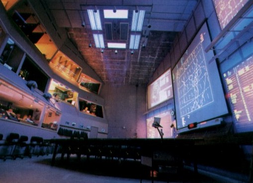
The requirement, and original plan, was for several more modern command posts though, but budget issues prevented that. As a result a plan was conceived for converting a number of the pre-existing older style command posts into functional ones. Still expensive but less so. These were called the Type IIs, four of these were eventually brought online. They were also hardened underground ones, but to a lesser degree than the Type Is as these had originally been built prior to the advent of highly accurate nuclear weapons. The electronic setup was also somewhat different than the Type I, as these excluded the fighter controller function and were also laid out around a central command room. These were referred to as the "church" due to their high ceiling height.
A few photos of these exist:
Unlike the Type I these also retained the manual chart table from their predecessors, this was also a cost cutting measure as it was used to plot the input from visual air observers rather than feeding it into a digital system which would have required more operator stations and such. The observers were kept around for a long time even after radars became the norm, this seems to have been due to two main reasons. Firstly, in the event that all radars were taken out in an area they still offered some basic idea on if air raids were happening, allowing some degree of early warning to areas further away. Secondly, they could observe and report on nuclear detonations with direction, distance and mushroom cloud height quickly. This enabled some degree of quick overview to what targets had been hit and at what yields. These reports were received by telephone by another type of command post called the LGC before being transmitted to the LFC for inclusion in the air picture. The LGCs also acted as emergency backups to the LFCs, with a largely manual handling of the air picture in case the LFCs were taken out.
The manual table can be seen better here:
The digital radar information was however displayed by projectors on the large wall as seen in the photos above, and was data linked between the LFCs and RRGCs. On the sides raid designations and other data such as altitudes and speeds were displayed. It also came with some fairly modern functionality, such as the ability to display cursors (controlled by trackballs from three stations) that could be used to point to raids and such while giving orders to the RRGCs over voice link. An oddity with these complicated big screen projectors was in the way the past track of each raid was displayed, this was done by a laser continuously burning tiny holes in a plastic film that the projection was displayed through. These holes then appeared as dots trailing each raid and indicating the past position. When desired, an operator cycled the plastic film forward with a button press and the past tracks cleared. This was a pragmatic way of avoiding to tie up processing power that would otherwise have been needed to display this.
The final LFC type was the type III. This was a single command post that got a much more modest upgrade, without the big screen projectors. It seems to have not done much in the way of actual commanding but was rather kept to act as a sort of filter central for the visual air observations in the area, the closest higher end command post would have otherwise have had to handle too much of this information on its own.
So the RRGCs then, can be split into two groups. The RRGC/F, and the RRGC/T. The F ones were fixed hardened ones, and the T ones were mobile setups. Originally it was only planned for the fixed variety, 13 in total, but budget cutbacks limited these to just 8. As a fix four mobile variants were later developed, with the equipment mounted in a number of trailers each.
These were in peacetime normally set up above ground at air bases but would at certain readiness states move out and set up at one of a number of prepared wartime locations. At least one had its primary location inside a hardened space adjacent to an LFC, in other cases they were intended to set up in a hardened space by a radar station, as seen here:
One advantage with the overall setup of the air defense communications system and datalinks was that there were a fairly large number of locations that these could hook into the net and operate from, so it made it harder to determine where they were and take them out.
Interior shots of an RRGC/F:
The were some capability differences between the two. The RRGC/Fs could handle a 1,024 square kilometer area up to an altitude of 39,800 meters. The RRGC/Ts could handle a 2,048 square kilometer area to the same altitude. The F could track 73 raids simultaneously and pass on information on 70 of these to LFCs or other RRGCs via datalinks, whereas the T could track 72 raids and pass on information on 60 of these. The T could receive information on 143 raids from other centers, but I don't know what the corresponding figure is for the F. The F could direct 16 intercepts at the same time while the T could only handle 12.
Overall the system was very modern, and capability kept being added to it. Early on one way datalink functionality to interceptors were added which enabled the RRGCs (and type I LFCs) to send intercept commands digitally to Draken fighters. These were displayed on the flight instrumentation as desired altitude, direction, speed, type of attack/target and such. When the Viggen interceptor variant came online this was changed to the target data being transmitted instead and the intercept calculations were handled by the onboard computer instead, and more details could also be transmitted as well as the fighters being able to feed data back into the system.
A switchover to primarily narrowband transmission of radar data in digital form also meant that the information from every radar station could essentially be fed into the nationwide system, and every LFC and RRGC could operate in any area of the country if needed. This improved redundancy as even if a number of centers in say the north was knocked out, the ones in the south could still handle the area as long as radar information was still available. It also meant that handling peacetime alert operations became easier and cheaper as only one LFC and one RRGC needed to be online and staffed at any given time, and could still manage the whole show with all the radar data, radio comms and such being available to them. It should be noted though that they kept having issues with the handover between different centers up until the end, with them usually having to try several times before the system would hand over control from the old to the new center. A quirk in the setup.
In conclusion, in the 90's a new system began to enter service to replace this and the final LFCs were shut down in 2001, with the final RRGC/T being left in service until 2005 as the new system wasn't set up for data linking with the Viggen fighters (only the Gripens) who left service in the same year.
Both the LFCs and the RRGCs were replaced by a new type of center which combined the functions, called the StriC. The two LFC Type I facilities were expanded with a new area underground in which the StriC equipment was installed, and then the old areas were cleared out and repurposed for other uses. When they were inaugurated they were said to have around 200 operators at full staffing. Two above ground centers for exclusively peacetime use were also added, called LEs. The staff there are supposed to "go somewhere else" in wartime, so you can draw your own conclusions about that. And finally, the old centers all had animal call signs, and the new ones continue that tradition although since 2010 they are in English so as to be more usable internationally. Hence the two StriCs that officially exist have callsigns Grizzly and Cobra, and the LEs have Eagle and Blue Shark. Cheers!